We loosely followed Raff's trip report instead of the traditional route described in Chic Scott's Summits and Icefields 1994 edition.
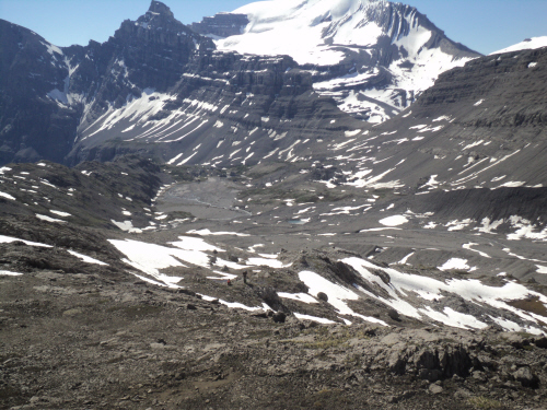
After travelling above the north shore of Coleman Lake, head north-east to the pass leading into White Goat Wilderness Area, 043759. From the pass, drop down to the meadows while traversing towards Huntington Glacier. We chose to bivi next to Huntington Creek, 038777. Gain the rib that leads to a spine situated at the north-east edge of the glacier, 025787. Skirt the spine climber's left and traverse to the south slopes of Cirrus Mountain.

Fab was convinced that Cirrus Mountain would be a better ascent in the summer, eliminating avalanche hazard on the approach. After scrutinizing Google Earth and Raff's trip report, he figured we could avoid the glacier. Travelling light was definitely appealing for this arduous outing. We planned a two-day trip mainly to get an early start and take advantage of firm snow on our climb.
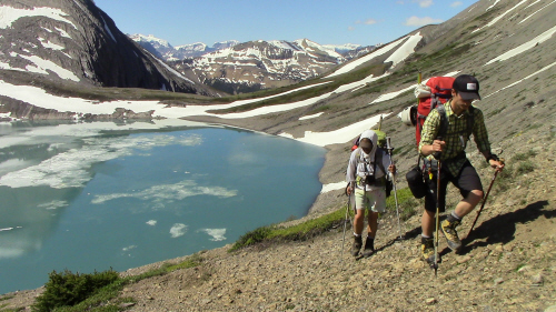
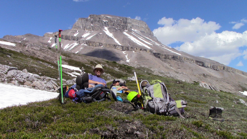
Approach: 6 hours to bivi. We met Charles at the pull off early to beat the forecasted intense heat. The climb to the first lake is steep but trees don't choke the terrain and there's lots of game trails. Nearing the first lake, we travelled at the trees' edge high on the mountainside, climber's left. Upon reaching the lake, we dropped down to it's shore. Coleman Lake is a short distance away and most of the height has been gained; the scenery is spectacular, Mount Coleman steals the show! Reaching Coleman Lake stirred a lot of emotion in both Fab and I, we thought of Winston a lot... The beautifully colored lake seemed less hostile this time. We replenished our bottles at an inflow and started a high traverse above the lake to gain an obvious ramp. We were able to find an easy way up through the rockband from the ramp; at that point, we got our first glimpse at the objective (Chic Scott's route). We continued traversing towards the pass, excitement was building. From the pass, we aimed for the last grassy spot closest to Cirrus. After more sidehilling on talus slopes, we settled in next to the creek. We spent the afternoon rehydrating and gawking at Mount Coleman since we could only see the top of Cirrus. It was so hot that we took shelter under a tarp to avoid heatstroke. The minute the sun set, we put on layers and retired for the evening.
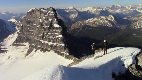
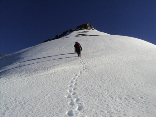
At 4:20 AM I suddenly woke up and asked Fab what time it was. The alarm was not set at the proper time and we slept in a little. In no time, the stove was boiling water and the shelter was dismantled. Shortly past 5 AM, we set off towards the mountain following a rib north of the drainage. We quickly reached the spine and were thrilled to see a straightforward traverse to the ascent slope. The snow was firm and travelling was pleasant. Cirrus Mountain's southern outlier is dramatically stunning, it demands attention. We climbed on rock until we got to the snow pitch below the ridge crest. We traded poles for axe and crampons and continued to gain the ridge. Once on the ridge proper, majestic scenery towards the Columbia Icefield is revealed; the surrounding landscape is equally awe inspiring. We carefully proceeded on the snowy ridge, encountering a couple of very short hands-on sections. As we ascended the last snow slope before the top, I was in disbelief; we would finally stand on the summit of this impressive mountain. We reached the top before 9 AM, I was elated! The views are outstanding, the north-east connecting ridge called Mare's Tail is heavily corniced and quite the sight. We didn't stay too long, wanting to avoid the softening snow. We looked for a register but couldn't find one, good thing Fab came prepared; he left a nalgene bottle with a notepad and a couple of pencils. In the bottle we left a couple of prints of Winston and his rubber dog bone. Returning was fast; after picking up our poles, we glissaded the whole snow slope. I walked on a cloud all the way back to camp! We took a fine break as we packed our things. It was already hot with no clouds in sight. We left the meadow reluctantly and slowly made our way back up to the pass. We backtracked along the lakes, stopping to drink water often. Once in the trees, we continued carefully to avoid getting cliffed out. We surprised a black bear; I guess we weren't as loud as we should have been... We made it to our vehicles feeling very content and tired. This was truly a memorable outing in the beautiful Rockies!